(All photographs by Mike Nash)
Introduction
I have hiked and backpacked in Canada for 50 years, many times off trail and in less traveled parts of British Columbia. My hikes into the more remote places in northwestern B.C. were with small, informal groups of two to four people, while other trips such as our recent Rainbow Range hike in South Tweedsmuiri were with larger, organized parties. Two years ago, having reached the liberating age of a septuagenarian, I decided on an impulse to solo hike the populous Skyline Trail in Jasper National Parkii .
High profile trails like the Skyline can book up months in advance, but it’s possible for an individual or single tent party to take advantage of cancellations at short notice if your itinerary is flexible. That flexibility is one of the benefits of retirement, and short notice means a decent chance of finding good weather. My wife was away in eastern Canada when I hiked the Skyline Trail for the first time, so the following year, in July 2018, we repeated it together.

The Brazeau Loop
What to do next? Judy had arranged a road trip with her sister in July 2019, so I planned a five-day solo backpack of the 81-kilometre Brazeau Loop in southern Jasper National Park while she was away. This hike is described on the park’s website as the ‘grand tour of the southern ranges’ and is said to be one of the best in the Canadian Rockies. Nearly twice the length of the Skyline Trail, it goes over five high mountains passes, with river valleys, subalpine forests, a large subalpine lake, and alpine meadows in between, all with interesting geology, flora and fauna.
The main access point is the Nigel Creek trailhead in Banff National Park near the midpoint of the Jasper-Banff Icefields Parkway, meaning that it is equally accessible from South and North Central BC and Alberta. And for me, one of the great things about living in B.C.’s northern capital is that we are only four hours from Canada’s Rocky Mountain parks on scenic and lightly traveled highways.
First Attempt – Decision to Turn Around
The summer of 2019 began without the pervasive wildfire smoke of the previous two years; but the cool, wet spring meant a late start to the backcountry hiking season in the Rockies. As I prepared to leave for my hike, Parks Canada’s website still showed all the Brazeau trails to be in poor condition, with wet and muddy sections. As well, looking ahead to my fourth day crossing of Jonas Shoulder and Jonas Pass (the crux of the route), the forecast was for rain and snow, which was in fact what happened.
On top of this, it rained all night and most of the day going in, so that my gear was damp before I even started the hike. I overnighted in Mount Robson Park, lingered over coffee and snacks in Jasper, and took my time driving to the trailhead in rain that was at times heavy. Consequently I got a late start at 3:30 p.m. in the afternoon on July 24th, and just two hours later I made the difficult decision to turn-around just before Nigel Pass. Knowing when to stop is a key factor in having a safe, enjoyable experience in the backcountry, but that doesn’t make the decision easy.
Apart from trail conditions and weather, there were other factors bearing on my decision to turn around that afternoon: At age 73, and especially hiking soloiii, there was a non-trivial possibility (and consequence) of a slip and injury in the prevailing conditions. As well, the Brazeau Loop is known for grizzly bear encounters, which later proved to be the case for me. Added to that, my new lightweight backpack wasn’t working well, with too much weight for the pack size; my right knee was bothering me; plus I had not done anything this big for several years.
As I hiked towards a go/no decision that afternoon, I mentally went through a risk assessment and concluded that I was ticking too many boxes. Backcountry accidents usually result from multiple contributing factors and small decisions. It’s important to pay attention to such details, and especially to whether what you are doing still feels right. It was a hard choice to turn around after so much preparation and anticipation, but in hindsight it was the right choice for me at that particular time. Of course, that didn’t stop me from second-guessing the decision all the way back to the cariv .
In truth, it was a finely balanced choice; if just one factor had been different, such as my backpack feeling OK, I would likely have pushed on. As it was, I had covered some new ground most of the way to Nigel Pass, and there would be fewer unknowns for a possible retry. With an uncomfortable backpack still heavy with six days of food, it was after 7:30 p.m. when I reached my car, and midnight when I got back to Prince George, having failed to find a vacant campsite enroute.
Next morning, a phone call to Parks Canada got me a partial refund, and a few days later I rebooked the Brazeau Loop for late August. In the meantime, Judy and I joined the Caledonia Ramblers for the weeklong Rainbow Range hike, which turned out to be an enjoyable and successful trip. By late August, boosted by the psychological and physical conditioning of that comparable backpacking trip; with knowledge gleaned from my July reconnaissance, and with one of the better weather windows of the season for Jasper National Park, I was, as they say, ‘good to go’ for a second solo attempt.
Second Try – Not So Immutable Landscapes
Leaving the trailhead at 2 p.m. on August 25th, I hiked the first two kilometres of fire access road to ‘Camp Parker’ which, in the early years of the Icefields Parkway was the halfway stop in what was then a two-day drive. Descending to Nigel Creek from Camp Parker, I was immediately confused by what I saw: everything had changed since I was there in July. The footbridge over Nigel Creek was gone, and there was a tangle of freshly uprooted trees that had obviously come from somewhere else and smelled like fresh-cut lumber in a working sawmill. The trees were strewn about a wide debris field of boulders, overturned vegetation mats, and other materials. There had been no warning sign at the trailhead, nor anything on the park website the day before, suggesting that the destruction before me was quite recent.
I walked up and down the now turbid creek looking for a way to cross. Since this was only the first, and hitherto benign-looking creek-crossing of the trip, what would the rest of the route be like? I was apprehensive that I would encounter a lot more of the same, and once again I considered abandoning the trip. That would have been a mistake, because I later learned that this had been caused by a localized debris slide higher up Nigel Creek rather than a general weather event.
We often think of mountains as immutable, but apart from this new slide I saw plenty of evidence on this trip of old landslide activity in not-so-geological timeframes. I also learned that two day-hikers on the popular walk up to Nigel Pass had found themselves benighted by the debris flow. They had spent the night huddled under a tree within sight of the highway, waiting for the torrent to abate so that they could cross. This is illustrative of why day hikers need to be prepared to spend one or two unexpected nights out, even on popular and easy trails.
In the meantime, there was a single tree bridging the creek, and by extending my trekking poles to the maximum, I found that I was able to feel the creek bottom and inch across the log without getting my feet wet. I was barely half an hour into the trip, and I had already had my first adventure.
Flawed Backcountry Reservation System
I made good time after that, leaving Banff and entering Jasper National Park in the confused and rugged terrain of Nigel Pass. At this place, the Great Divide Trailv joins the Nigel Pass, Brazeau and South Boundary Trails, having crossed Cataract Pass from the White Goat Wilderness four kilometres east-southeast of Nigel Pass. The GDT is beginning to see more hiker traffic, with several people reportedly coming through this summer; although managing their backcountry camping permits in the national parks with a necessarily flexible itinerary must pose a challenge for through-hikers. If we are serious about developing long distance hiking trails in Canada, like those south of the border, there should be a one-stop, flexible permitting system for through-hikers in the national parks.
After a rock-hopping creek crossing at Nigel Pass, the trail first climbs through a boulder field and then quickly descends to the headwaters of the Brazeau River in a flourish of new scenery. Emerging from a rocky cascade, the nascent river meanders through a verdant meadow to pass under a narrow bridge that leads to the Boulder Creek campsite. Most hikers prefer to continue on for another three kilometres to the larger Four Point campsite, but that was already fully booked when I made my reservation.
Boulder Creek had also shown as three-quarters booked, but I had it to myself that first night. This reflects a failing of the reservation system in that every campsite I stayed in had several no-shows, meaning that people are being turned away needlessly. The same thing is happening in Mount Robson Provincial Park on the popular Berg Lake Trail, where it has become hard to get reservations while some tent sites go unused. I recognize the irony in that I had contributed to this on my first Brazeau attempt, but the backcountry reservation system needs rethinking, perhaps with trailhead and through-hiker quotas rather than fixed campsite bookings.
Boulder Creek is a pleasant, but brushy campsite, albeit a bit spooky when there alone. I arrived at about 6 p.m. and I had just got my tent set up when it began to rain. The shower only lasted for an hour, but it was enough to soak the tent and the underbrush crowding the trail, and complicate the next morning’s departure. I thought about setting up my new lightweight tarp to cook supper under, but that wasn’t necessary as the campsite is blessed with a large tree that shelters one end of a picnic table from the rain.
Brazeau River and Brazeau Lake

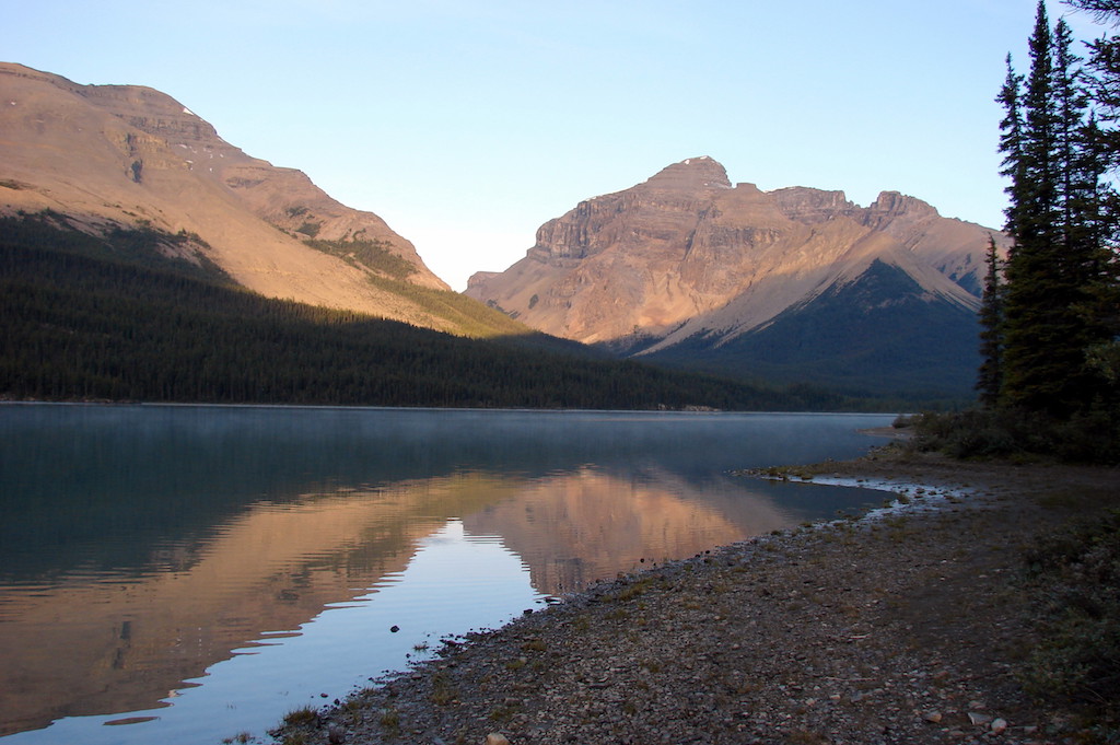
After a pleasant night under a brilliant star-filled sky, I had a leisurely start the next day. An hour later I passed the Four Point campsite at the intersection of the Brazeau River and Jonas Pass trails. If things went well, I would be returning to this camp from Jonas Pass on day 4. In the meantime I had the longest stretch of the hike in front of me that day, a total of 21 kilometres along the Brazeau River from Boulder Creek to Brazeau Lake. The trail was mostly flat and in good shape, alternating between forest and brushy meadows, and generally quite scenic. The bugs were non-existent, although I’m sure it would be a different story earlier in the season. I made good time despite my late start, arriving at the five-kilometre long, azure-coloured Brazeau Lake at 5 p.m. to find one couple camped there. They generously shared some excellent single malt Scotch with me later that evening.
There was one unusual thing about the hike along the Brazeau River. On the first afternoon I had paused to chat with an older hiker who was coming out, and who went to great lengths to explain to me how best to ford the Brazeau River. Accordingly, I spent the entire second day needlessly wondering where the ford was and how I was going to cross. I can only surmise that this individual, who otherwise seemed to know the area well, did not know that the hiker trail had been relocated entirely to the west side of Brazeau River some five years earlier, and that a ford was no longer necessary. I could only wonder what route he had taken. The Brazeau River section of the loop used to have a poor reputation with hikers who had to share the muddy trail on the east side of the river with horses.
The Brazeau Slide

After another pleasant night, I packed up my camp early on day 3 and retraced the 400-metre side trail back to the rustic bridge crossing the northwest fork of the Brazeau River, whence I began the climb around the lake that would lead me to John-John Creek and eventually to Poboktan Pass. The trail soon emerged from the forest and crossed an interesting and fairly young geological feature, the Brazeau Lake Slide. It had occurred in 1933 on a mountainside southwest of the lake, and ran two kilometres to reach into the lake. It was apparently a slow-moving debris slide, and the first park warden on the scene, Charlie Matheson, reported that the ground was still quivering. It was this quivering that formed numerous and distinctive conical mounds called mollards, which are believed to have been built by the sifting and sorting of rocks and debris. The slide was the ‘largest landslide in the 20th Century’ according to one guidebook, although it doesn’t qualify what that was relative to.
After crossing the slide and John-John Creek, the trail works its way up John-John valley until it reaches a large, remnant terminal moraine that likely marked the maximum glacial extent at the end of the Little Ice Age around 1850. John-John Creek has since forced its way through the moraine, causing me to wonder if the breach might have released a glacially dammed lake and contributed in some way to the Brazeau Lake Slide.
Poboktan Pass

After climbing around the moraine, the trail passed through the John-John campsite which was deserted at mid-day, and then climbed steeply out of the forest into the wide alpine meadow approach to Poboktan Pass. This three or four kilometre long scenic pass was the best surprise of the trip. The weather held fine, golden eagles wheeled overhead, and I very much enjoyed my slow wander through this delightful area with stops for snacks and water. I caught up with my campsite companions of the night before. They had paused to allow one of them, a professional artist from Edmonton, to make well-rendered pencil sketches of the scenery, while her partner made coffee for them both.
As the afternoon wore on, I crested the pass and began the descent down to the Poboktan Valley and the Jonas Cutoff campsite, from where I would begin my return leg of the circuit the next morning. The name Poboktan is taken from the Stoney word for owl. Enroute, I passed an old steel post and insulator that used to carry a telegraph wire over the pass. These lines were installed in the 1920s to provide emergency communication with remote warden cabins. They have long since been replaced by modern devices such as satellite phones, but remnants of the old lines can still be seen.
Jonas Cutoff
Jonas Cutoff is a popular campsite, situated at the junction of the Brazeau Loop and the Poboktan Pass trail, an alternate access originating at the Sunwapta Warden Station. Set in a ravine, this attractive campsite is the staging point for the hardest and (in good weather) the most spectacular part of the Brazeau Loop: over Jonas Shoulder and down through Jonas Pass. At 9 p.m., however, it began to rain, and this continued through the night. Rain on the tent can create a peaceful atmosphere that is conducive to sleep, but on this occasion it had the opposite effect as I contemplated the next day’s crux hike.
At 5 a.m. the following morning the rain stopped. Still restless, I took advantage of the respite to pack up my gear and cook breakfast. By 7 a.m. the skies had mostly cleared, and ten minutes later I was underway. The two other tents at the site had yet to show any sign of their occupants stirring as I quietly hit the trail. I climbed alone into the picturesque morning, with alpen glow on the ridges around me. I soon left the trees behind and climbed into my own personal alpine sunrise, pausing a few times to take photographs in the early-morning light.
Grizzlies
In the tent the night before I had been reading from the last, unfinished work of renowned First Nations author, Richard Wagamese. In it, he talked about the importance of peripheral vision while walking, especially with a tendency to look at one’s feet on rough ground. He described an exercise of holding one’s arms out to the side with the thumbs up, finding the spot where you can first see them in your peripheral vision, and then trying to maintain that peripheral awareness. I practiced that as I climbed up through the alpine meadows below Jonas Shoulder that morning. Sometimes the universe just speaks to you, as I was about to discover.
Suddenly, I became aware of movement above and to the right of me. Focusing on that spot I identified what appeared to be a young adult grizzly bear coming more or less directly towards me. Simultaneously, I became aware of an animal calling somewhere off to my right, but I was so focused on the bear that I only half-consciously registered the sound as an elk or some other animal to be checked out later. This is the tunnel vision effect that can occur in high-intensity, surprise, and/or survival moments; and it is why Wagamese was suggesting practicing peripheral awareness. Continuing to focus on the grizzly that was closing in on me, I decided that it needed to know for sure that I was there and that I was human. Waving my arms, I yelled “Hey!” a few times, at the same time un-holstering my bear spray and climbing sideways away from the trail.
Having done all that I could to mitigate the situation, I decided that I might as well start taking photographs, which is something I have generally avoided during prior grizzly encounters in favour of active avoidance. I also turned my attention to the continuing cries below to my right, which were now sounding like a cross between an elk bugling and the distant roar of Hollywood’s ‘Bart the Bear.’ I quickly identified a second grizzly that appeared to be calling the first bear, and I surmised that I was dealing with a female and a three-year old cub. Unlike black bears that break up their families in the second year, grizzlies often keep their cubs for three years.
I realized that I was in a different situation than I had first supposed, especially as a second big cub now ambled into sight above the first. I was at one corner of a triangle, with two curious three-year olds ‘feeling their oats’ at a second vertex, and a clearly frustrated mama bear at the third. High-spirited teenagers came to mind. If I had had better peripheral awareness, I might have seen the mother sooner and I most definitely would not have waved and shouted at her cub. However, she was tolerant of my presence and continued calling to the cubs until they eventually acquiesced and ran down to join her. The maturity of the cubs, the open country, and her obvious familiarity with hikers were likely factors in her tolerance, and my favour.
I later learned that the two Edmonton backpackers came up about an hour behind me and encountered the same bears, also without incident. By then, the bears had apparently had enough of people and took off at a high rate of speed. I was impressed watching and filmingvi the cubs during my encounter as they ran down to their mother. Don’t ever think of trying to outrun an animal that can match the speed of a race horse even on uneven terrain.
Jonas Pass

The early morning adrenaline helped offset any lingering effects of sleep deprivation, and boosted me to the high point of the trip over the 2,450 m (8,038 feet) Jonas Shoulder. There, I was instantly treated to a spectacular sun-lit view of the still partly glaciated Jonas Valley. One of the delights of cresting a new mountain ridge is the whole new world that is suddenly revealed on the other side.
Descending, the path led for another 16 kilometres over Jonas Pass and down to my final camp at Four Point. Jonas Pass was so long and gradual that it was hard to discern the apex, save for a small unsigned cairn where I paused to snap a selfie. Except for the last few kilometres down to the Brazeau River, it was all wide open alpine with generally low relief and several hanging glaciers above the south side. I passed two young women hikers going the other way and I warned them about the bear, as did the Edmonton couple later; I was not sure from their expressions that they appreciated knowing. There is no overnight camping allowed in Jonas Pass and the entire Jonas section must be completed in one day. The pass is named for Chief Jonas, a Stoney elder who first told University of Toronto geologist/explorer, A. P. Coleman about the route in 1893.
The rest of my trip went without incident, and on day 5 I hiked back over Nigel Pass to the trailhead to wind up one of my most memorable backpacks ever. Hiking alone allowed me to go entirely at my own pace and to be thoroughly engaged with the country. Yet I was never completely alone, meeting occasional hikers on the trail once or twice a day, and having company at every campsite save the first. For safety, I had left a detailed itinerary and map with my wife, and I carried a PLB with me for use in an emergency.
If You Go
The best time of year is likely mid-July to early September. For up to date information, visit Parks Canada’s websites for Jasper National Park Backcountry Campingvii and Trail Conditionsviii.
Maps
1:50,000 Canadian Topographical Map 083C06 Sunwapta Peak. The ‘Friends in High Places’ version includes national park trails, but lacks the legend on the back that government topo maps typically have.
1:100,000 National Geographic Series Map 902 for Jasper South / Jasper National Park. The NG topo map is waterproof, tear-resistant, packed with additional information and, by virtue of its smaller scale and using both sides of the sheet, it covers a much larger geographic area, including the Poboktan Trail alternative access / escape route.
I took both with me, having purchased them at the Jasper Visitor Centre. While a good map isn’t absolutely necessary in good weather, it definitely adds interest to the hike and would be essential for navigation in bad weather or whiteouts in the high mountain passes, or if you should get off the trail somewhere.
[i] See‘Rainbow Reprise’ by Dave King, in this issue.
[ii] Skyline Hike, July 2017: https://www.youtube.com/watch?v=Ep8WzNeTA5E&
[iii] For a discussion on the pros and cons of hiking solo see ‘How to hike grizzly country’: http://www.doctorsreview.com/features/how-hike-grizzly-country/
[iv] Nigel Pass, July 2019: https://www.youtube.com/watch?v=8BVpc-I3_AM
[v] The Great Divide Trail: http://www.greatdividetrail.com/
[vi] The Brazeau Loop, August 2019: https://www.youtube.com/watch?v=PfdaCDoYmlc&list=PLy0NTkFnAEe2cQl0jjesyfu_1YVgcrQ1g&
[vii] Jasper National Park Backcountry Camping: https://www.pc.gc.ca/en/pn-np/ab/jasper/activ/passez-stay/arrierepays-backcountry/sugg-sentiers_trip-ideas/Brazeau
[viii] Jasper National Park Trail Conditions: https://www.pc.gc.ca/en/pn-np/ab/jasper/activ/activ-experience/sentiers-trails/etat-sentiers-trail-conditions


Thanks for a wonderful description and overview of your experience on the Brazeau Loop. I have this booked for mid September of this year and already am very excited as I anticipate the adventure ahead of me. Take care!